Filter by Keyword
- Uncertainty 1
- mortality 1
- incidence rate 1
- geographically weighted regression 2
- E2FCA 1
- Illinois 1
- Equity 1
- Disparity 1
- Race 1
- Pandemic 1
- 1918 1
- Racial Trauma 1
- Social Determinants 1
- Influenza 1
- COVID-19 8
- ICU beds 1
- Spatial Accessibility 1
- Python 1
- CyberGISX 1
- public transit 1
- spatial access 2
- Google Cloud 1
- geocoding 1
- vaccine 2
- html 1
- webscraping 1
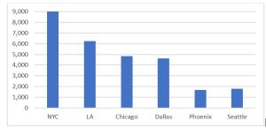
- NYC 3
- Geospatial Fellows 4
10 notebook results
COVID-19 Webscraper
Posted by Xiang Chen on Thursday January 13, 2022
This notebook scrapes the list of COVID-19 vaccination clinics from NYC COVID-19 and Flu Vaccine Finder (https://vaccinefindernycgov/) You can also use it for other ...
COVID-19 Vaccine Geocoder
Posted by Xiang Chen on Thursday January 13, 2022
The notebook geocodes a list of COVID-19 vaccination clinics based on their addresses You can also geocode other address data (eg, grocery stores, banks) using the notebook The notebook uses the ...
NYC COVID-19 Vaccine Finder
Posted by Xiang Chen on Thursday January 13, 2022
Vaccination is the primary preventive measure to battle against the COVID-19 pandemic In New York City (NYC), reaching a vaccination clinic is highly reliant on public transit This notebook helps you ...
Food Access During the COVID-19 Pandemic
Posted by Xueting Jin on Friday December 17, 2021
This notebook provides the code for running a Segmented Linear Regression Model to examine visits to grocery stores in six large metropolitan statistical areas ...
Stochastic-distribution-of-spatial-accessibility-to-ICU-beds
Posted by Jinwoo Park on Thursday November 11, 2021
The accessibility and availability of intensive care unit (ICU) beds are particularly critical in the context of COVID-19 because they are closely related to the fatality rate of the disease As the ...
Lessons (Not) Learned: Chicago Death Inequities during the 1918 Influenza and COVID-19 Pandemics
Posted by Matthew De on Friday November 5, 2021
This notebook compares the outcomes of the 1918 Influenza pandemic with the outcomes of the current COVID-19 pandemic for Blacks in Chicago ...
Spatial Accessibility to ICU Beds and Ventilators in Illinois
Posted by Admin CyberGISX on Monday August 23, 2021
This aims to measure spatial access for people to hospitals in Illinois The spatial accessibiilty is measured by the use of an enhanced two-step floating catchment area (E2FCA) method (Luo & Qi, ...
Data Location:
- Illinois
Identifying High Accuracy Regions in Traffic Camera Images to Enhance the Estimation of Road Traffic ...
Posted by Yue Lin on Thursday July 15, 2021
This Jupyter notebook illustrates a quadtree-based algorithm to establish the image regions with high vehicle detection accuracy A case study is presented to demonstrate how the use of these high ...
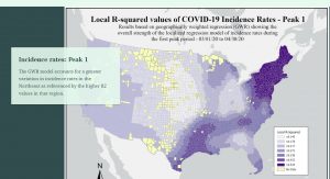
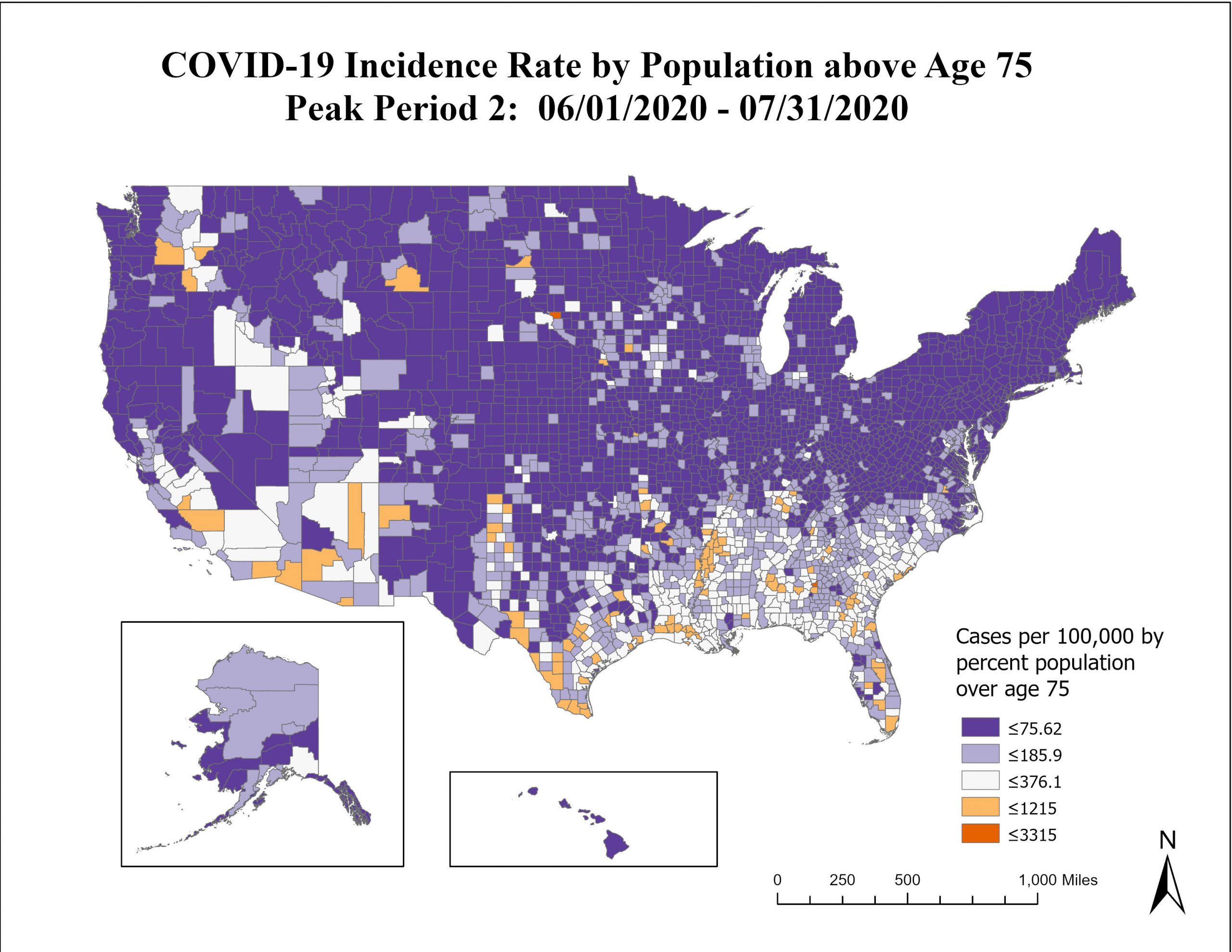
Geographically Weighted Regression (Part I): COVID 19 Incidence
Posted by Naomi Lazarus on Wednesday June 30, 2021
This notebook provides the code for running a Geographically Weighted Regression (GWR) using COVID-19 incidence rates as the dependent variable and independent variables representing age and ...
Geographically Weighted Regression (Part II): COVID 19 Mortality
Posted by Naomi Lazarus on Wednesday June 30, 2021
This notebook provides the code for running a Geographically Weighted Regression (GWR) using COVID-19 death-case ratios as the dependent variable and independent variables representing age and ...
Filter by Keyword
- bottom-up 1
- Community Detection 1
- COVID-19 9
- Credibility 1
- Cybergis 2
- Disability 1
- epidemic modeling 1
- Food access 1
- Food environment 1
- high-performance computing 1
- Incidence 1
- individualization 1
- Migration 1
- Mobility 1
- Modularity 1
- Mortality 1
- Networks 1
- Policy 1
- Regional Science 1
- Regions 1
- Replicability 1
- Replication 1
- Reproducibility 1
- Reproduction 1
- Social Media 1
- Social Vulnerability 1
- Spatial Accessibility 1
- spatialization 1
- Travel behavior 1
13 blog results
Food Access During the COVID-19 Pandemic
The COVID-19 pandemic has significantly affected daily activities and travel behavior worldwide ...
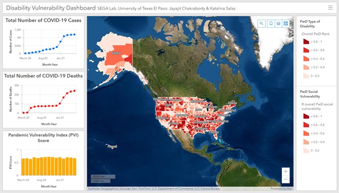
Developing a Disability Vulnerability Dashboard
Authors: Jayajit Chakraborty and Katalina Salas, Socio-Environmental and Geospatial Analysis (SEGA) ...
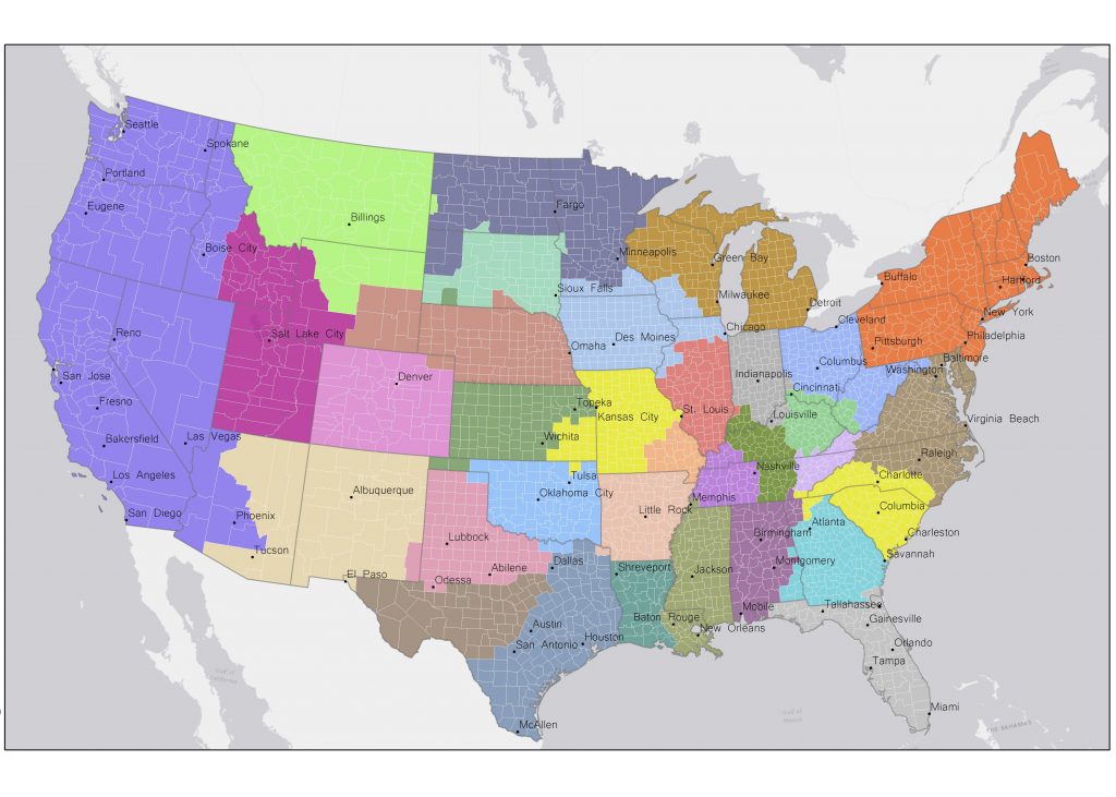
Building Effective Regions for COVID-19 Policy Administration (Or: How Our ...
This work is conducted with Caglar Koylu (University of Iowa) and Mason A Porter ...

Reflections on the Geospatial Fellowship program
My experience working on the GSF project has been very rewarding and enjoyable I liked the ...
Story Map on COVID-19 Research
I have designed a story map summarizing the key findings of my GSF project that is concerned with ...
Bottom-up approach to epidemic modeling and access to high-performance computing ...
Epidemic modeling is to build models to represent, characterize, and simulate the spread of an ...

Middlebury College Students Reproduce and Replicate COVID-19 Health Care Resource ...
The Geospatial Software Institute Fellows for Advancing COVID-19 Research & Education program ...
Age and Morbidity Trends related to COVID-19
I am conducting a county-level assessment of COVID-19 in relation to age demographics and ...
Presentation: Working with Students to Reproduce COVID-19 Research to Establish ...
On October 19, 2020, Peter Kedron and Joseph Holler co-presented a workshop on reproducibility and ...